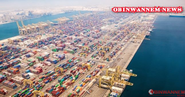
The youth wing of the Igbo socio-cultural group, ‘Ohaneze Youth Council (OYC),’ has urged the Federal Government to collaborate with South-East governors to ensure the dredging of Ibaka River, Oseakwa/Osemoto River, Azumini River and Obeaku River that would see them transform into a big seaport to boost the nation’s economy.
OYC protested protest via a press statement by its National President, Igboayaka Igboayaka on Sunday; noting the economic impacts and development the move will yield to the country.
The group further outlined various seaports located in the East as, Obeaku-Ndoki seaport in Ukwa-West Local Government Area of Abia, The Azumini River in Abia State and the Calabar Seaport; demanding their renovations.
The statement says, “Igboland has many access to the Sea, Rivers, Canals, Lakes, Waterways to Atlantic Ocean which has remained unknown to some Nigerians who has failed to learn the geography and history that is evident and factual on ground in Igboland and Nigeria. But for the avoidance of doubt and to educate the uninformed, we will try to outline factual and verifiable details of some of these areas in Igboland with potential seaports when dredged and developed.
“Obeaku-Ndoki seaport in Ukwa-West Local Government Area of Abia state is only 25 nautical miles to the Atlantic Ocean from the confluence of Imo River and Azumini (Blue River) in Abia state, which is a large and deep body water of high-flowing and rich rivers. It could be more readily and profitably accessed by ships. The Imo River, which originates from Umuaku in Isuochi of Umunneochi Local Government Area meandered its way up to Obeaku-Ndoki, from where it emptied itself into the Atlantic Ocean.
“The Azumini River in Abia State is also 25-30 nautical miles to the Atlantic Ocean capable of developing into a big seaport which can house big ships. Popularly referred to as the Blue River, Azumini is strategically located, connecting Abia state to Rivers and Akwa Ibom states. Many Igbo towns and villages in Imo, Abia, Anambra states and Anioma in Delta state are within 30 minutes to 1 hour drive to the Sea Atlantic Ocean.
“Right in Obeaku, there is a confluence point where the Imo River and the Blue River meet. The Obeaku confluence passes through Ikot Abasi in Akwa Ibom State. In Rivers state for instance, (along Bonny River) we have Portharcourt Seaport and we have the Seaport located in Onne, Eleme Local Government Area. This is Nigeria’s busiest seaport and ranks as the largest seaport in West Africa.
Did you know that while the Obeaku-Ndoki and Azumini Rivers is only 25-30 nautical miles to the Ocean, the Rivers State (Porharcourt Seaport) sits 40 nautical miles away from the Atlantic Ocean and Onne Port in River State along with Bonny River sits 50 Nautical Miles away from the Atlantic Ocean. To some, this talk about a Seaport in Abia state may sound unrealistic but, it is not far-fetched. Since Nigeria parades a galaxy of consultants in marine engineering, obtaining professional advice in this regards may not be far from reach.
“Also from the border of Abia State and Imo State to the port of Portharcourt, Bayelsa, Igwenga/Opobo, Ahoada, Ogba is between 30 minutes to 1 hour drive, and if one takes Azumini River or Imo River from the border of Abia and Imo States to the Ocean and seaport in Portharcourt, it’s less than one hour drive and if you go by Azumini River or Imo River by boat, vessels or barges, it will take about two hours to the Ocean and to seaports in Portharcourt and Bayelsa with goods and services for exports and imports. Compare that to Northern Nigeria, Kano, Kaduna, Maiduguri, Chad, Niger, Central African Republic which is about 2000 miles to 3000 miles to the nearest Sea or Ocean and which takes one from two weeks to one month for heavy goods and services to get to the nearest seaport or ocean for export or importation at a very high cost.
“Further inward by thinking of laying a bigger foundation of economic sustainability for not only Abia State but the whole of the South-East geopolitical zone by formally conceptualizing the establishment of a seaport at Obeaku-Ndoki, Azumini and Oseakwa (River Ulasi) Ihiala in Anambra State which is only 18 nautical miles to the Atlantic Ocean with 20 meters deep without dredging, would be of great advantage to Nigeria. The Ulasi River in Anambra state is the deepest river in Nigeria, strategically located and connecting the state with Imo, Delta, Bayelsa and Enugu states.
“The Calabar Seaport is dredged 45 nautical miles to Atlantic Ocean. Akwa Ibom Ibaka deep seaport is about 30 nautical miles to Atlantic Ocean without dredging and the best seaport location in depth and within Eastern Nigeria.
“The onus now lies on the Federal government to map out a master plan to dredge potential seaports in Igboland and rehabilitate those that has gone moribund.
Comrade Igboayaka O Igboayaka noted that there’s nothing authentic and factual in exclusive list except printing of Currency any other thing can be powered by state government, therefore he advised Governors of Igbo extraction to key in to dredging of all potential seaport that will launch ala Igbo to maritime business thereby reduced the high level of unemployment in Igbo land.”
Ugochinyere Onyechere reporring, Obinwannem News